Prophecy pages
..............................................
Hopi prophecies
..............................................

..............................................
Entering the 4th dimension?
..............................................
Nibiru / Planet X
..............................................
2012
..............................................
Earth Change News
..............................................
Pole Shift
..............................................
Ice Age due?
..............................................
Contact Crawford2000
..............................................


Home

Thousands of animals were found to be frozen in a brief moment of geological time. Ancient maps of Antarctica suggests that it too was 'frozen over' in a brief moment in time.

It has been suggested that approximately 12,000 years ago there was a displacement of the Earth's crust. The entire outer shell of the earth moved approximately 2,000 miles. When the Earth's crust shifted all of Antarctica was encapsulated by the polar zone. At the same time North American was His theory is based on the theory of Continental Drift - the continents of the earth have been slowly drifting apart over millions of years. This is possible because the outer crust of the Earth floats upon a semi-liquid layer. The theory of Crustal Displacement states that the entire crust of the Earth can shift in one piece like the lose skin of an orange.

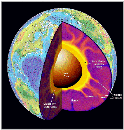
Prof. Hapgood who created this theory documented three Earth crust displacements in the last 100,000 years. Some researchers believe that they happen every 41,000 years and that the last one happened 11,500 years ago. Hapgood believes that this cataclysmic shift is caused by imbalanced ice at the polar caps. Over time ice builds up at the poles reaching as much as two miles in thickness. from the Arctic Circle and became temperate
.
The tremendous weight of the ice causes an imbalance on the globe. The ice shifts dragging the outer crust and the continents in one piece to new positions. The polar caps are now in a warmer climate where they begin to melt. The polar regions are now in a temperate climate where they begin to melt where temperate regions are in the polar regions where they freeze and build up ice.

Charles H. Hapgood was a history professor who began, at the prompting of some students, to look into the search for the lost continent of Atlantis. That lead him to the ideas of Hugh Achincloss Brown: that the entire earth could be made to be repositioned at a radically new angle on its axis of rotation.

Hapgood realized that the entire planet did not have to be repositioned around its axis. Only the outer crust need move, just as the loosely peeled skin of an orange could be slid around the unmoved inner slices. This line of thinking was published in Earth's Shifting Crust (1958), in collaboration with James H. Campbell, a mathematician-engineer.

Hapgood ultimately revised key parts of his thinking because his calculations convinced him that the mass of the ice cap on Antarctica could not destabilize the earth's rotation.

That book was later revised and in 1970 republished as The Path of the Pole by Charles Hapgood in which he said:

"Polar wandering is based on the idea that the outer shell of the earth shifts about from time to time, moving some continents toward and other continents away from the poles. Continental drift is based on the idea that the continents move individually. A few writers have suggested that perhaps continental drift causes polar wandering. This book advances the notion that polar wandering is primary and causes the displacement of continents. This book will present evidence that the last shift of the earth's crust (the lithosphere) took place in recent time, at the close of the last ice age, and that it was the cause of the improvement in climate."

Hapgood goes on to mention to two areas where he finds much of his evidence, in data derived from studies of geomagnetism and from carbon 14 dating. Although he argued that such global disruptions happened repeatedly, Hapgood by then was rejecting the idea that such disruptions could happen quickly.

Based primarily on that technical data, he argued that each shift took approximately five thousand years, followed by 20 to 30 thousand year periods with no polar movements. Also, in his calculations, the area of movement never covered more than 40 degrees. The presence of a truly liquid layer between the core and the outer crust would allow such slippage, moderated by inertial forces.

Looking down on the current North Pole, we can identify at least 3 previous positions of the pole, according to Hapgood. These are shown roughly by the numbered red dots below.

In his revised version, the movements to each of these positions were not cataclysmically fast, but relatively slow. Each took about 5000 years. According to his interpretation of the evidence, after each shift the new north pole remained in place for between 20 and 30 thousand years.

If the poles shift even as little (within 40 degrees) as Hapgood argues, then the equator moves in significant ways. This is shown below by the red lines on the paired views of the globe). Each pair shows two views of where the equator would be, roughly, for each position of the north pole shown above.

The changes in position are especially noticeable by where the equator cuts across the African continent in each situation--high, diagonally or low, compared to today.

The 3 different time periods

North Pole Position #1
From the Yukon area of North America at about 80, 000 B.P. and moving east by 75,000 B.P to the Greenland Sea.

North Pole #2
From the Greenland Sea, starting at about 55,000 B.P. and then moving south-west by 50,000 B.P. towards what is now Hudson Bay.

North Pole #3
From the Hudson Bay area at about 17,000 P.P. and moving north to its present location by about 12,000 B.P.

If the equator shifts, the line of tropics and sub-tropics also shifts. You can see the rough locations of shifts from deserts to 'jungles' because of equator relocations.

Notice that what is now Brazil--and the Amazon--are would be on the equator in all 3 situations. Saudi Arabia (and its potential for oil) would be very close in each situation.

Hapgood's chart of different locations of the North pole within the last 100,000 years.

MAPS - PIRI RE'IS MAP - HAPGOOD

The earliest maps supposedly were written on clay tablets and come from the ancient Babylonians around 2300BC. These maps were of land lots and were used to control taxation. There are maps made on silk from China around the 2nd century BC. The Mayans and Incas made maps of the territories they conquered. In the early 1300's navigators developed maps of the Mediterranean and other known coastlines. Finally in modern times we have perfected the art of map making and navigation. "Only since the late 1700's has it been possible to collect & record truly accurate geographic information

There is a map called Piri Re'is - dating from 1513, which was made by a man named Piri Ibn Haji Memmed, otherwise known as Piri Re'is. This man was an Admiral in the Turkish navy. Today we only have a fragment of the original map.

Piri claimed:

Charles Hapgood performed a detailed analysis of this map. He worked with students from Keene State College, as well as with cartographers from the US Air Force. After a detailed analysis, several interesting observations were made.

Conclusions:
Professor Hapgood presented a number of exhibits in his book, The Maps of the Ancient Sea Kings to support these claims. He also presented a plethora of empirical evidence to back up these points.

To understand the method of projection examine the following map. This is a section of an equidistant projection centred on Memphis Egypt. This map was produced by the US Air Force. Note the similar distortion of the coastline of the Americas between Piri and this map.

This map shows the superimposition of the portolan type projection on the equidistant projection. Note that the numbers on the outside of the largest circle correspond with projection points on the map of Piri Re'is.

The degree of accuracy contained in the Piri Re'is map is extraordinary. Given that the author of this map himself claimed to have based this map, not on his own surveying skills, but rather on ancient maps going back to the 1400's and earlier, serious questions about the development of navigation as we currently understand it.

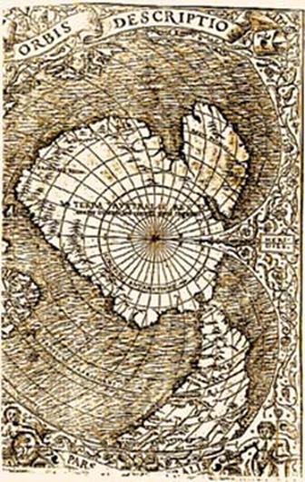
This is the Oronteus Finaeus World Map of 1532 - showing Antarctica.

Hapgood and his team converted this map from its current projection method into a modern projection method.

Compare the above with a modern map of Antarctica to see at a glance just how close they were.

This demonstrates that sometime in the history of the earth, before at least the 1500's a sea faring people existed that could circumnavigate the globe and accurately survey its features.

Atlantis, Mammoths, and Crustal Displacement
Rand Flem-Ath and Graham Hancock all write that an unknown advanced civilization existed on the Antarctica continent and was destroyed by cataclysmic shifting of the crust of the Earth.

Rand and Rose Flem-Ath in their book When the Sky Fell claim that the lost advanced civilization of Graham Hancock was Atlantis based upon a very liberal, loose, and speculative interpretation of the myth of Atlantis as told by Plato. Regardless of whatever a person chooses to call it, the main claim is that the remains of advanced, lost technological civilization lie buried beneath Antarctica.

One has to wonder - if such a civilization existed, why have the ruined cities, infrastructure, and other artefacts of a lost advanced civilization that made the source maps for the Piri Reis, Oronteus Finaeus, and Buache maps and inspired megalithic architecture not been found?

According to Graham Hancock Fingerprints of the Gods and Rand Flem-Ath, the solution is that the remains of this civilization lie buried beneath the Antarctic ice cap where it was destroyed and buried by Earth crustal displacement.